High-Resolution Model Developed for Tile-Drained Farm Fields
A new high-resolution model has been developed by researchers at the University of Illinois at Urbana-Champaign to better understand how water moves through agricultural fields with tile drainage systems.
A new study has shed light on how water behaves in tile-drained farm fields, a crucial aspect of modern agriculture that significantly impacts crop growth, nutrient transport, and water quality. However, despite its importance, modeling this complex process remains a challenge due to the numerous factors involved.
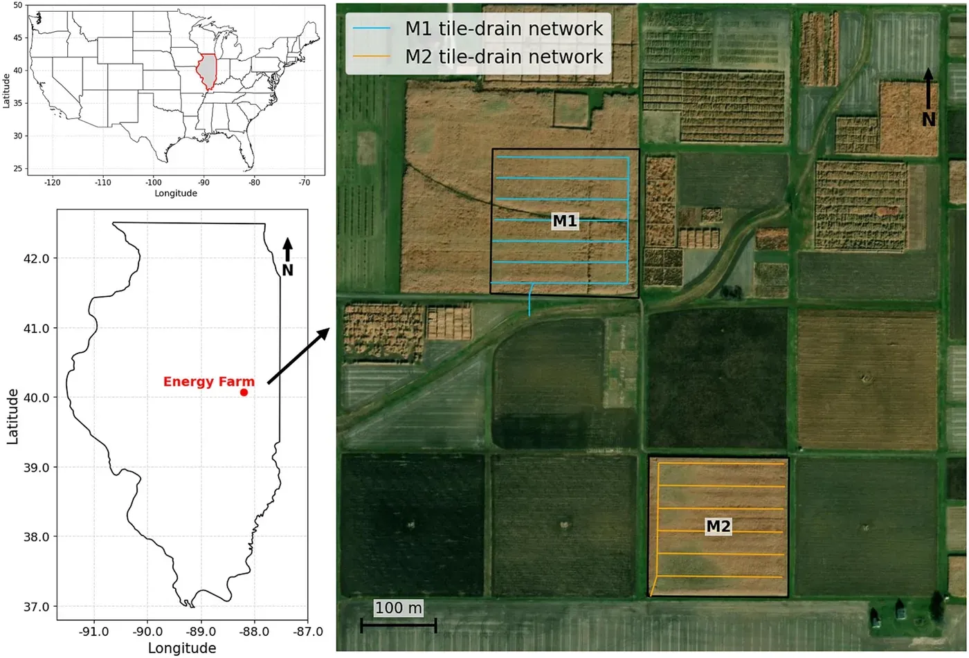
Researchers at the University of Illinois at Urbana-Champaign have developed a new high-resolution model to better understand how water moves through agricultural fields with tile drainage systems. The team used two test sites located on the university's Energy Farm to evaluate their model's performance and accuracy.
The study focuses on the critical differences in soil, topography, and tile design that can greatly affect the way water behaves within a field. Most current models fail to capture these variations at a detailed level.
Bin Peng, lead author of the study, explained that their new model provides an in-depth three-dimensional view of how water moves across the surface and through the soil after heavy rainfall events. This information is essential for farmers and policymakers who need to make informed decisions about agricultural practices and resource management.
The research team worked closely with collaborators at Oak Ridge National Laboratory to incorporate detailed maps of tile locations into their model, allowing them to test its effectiveness in real-world scenarios.
The model's ability to simulate real-world scenarios was enhanced by incorporating detailed maps of tile locations into its framework, a collaborative effort between researchers at various national laboratories.
By testing two approaches for representing tile drainage in the Advanced Terrestrial Simulator, the team discovered that both methods produced reasonably accurate results at the field scale. However, each approach had its own advantages and limitations depending on the specific research question being addressed.
One of the study's most striking findings was that simulations with varying resolutions, from 2 to 40 meters, yielded similar estimates of overall field-scale drainage once certain parameters were adjusted. This suggests that researchers may not necessarily require high-resolution models to estimate broad hydrological patterns.
According to first author Haoyuan Yu, even at a resolution as coarse as 40 meters, the model was able to reproduce the overall tile-drainage response with reasonable accuracy. However, when examining spatial patterns, significant differences emerged between the two resolutions.
The results indicate that while finer resolution is not always necessary for estimating overall field drainage or water-table response, it becomes increasingly important for understanding more nuanced aspects of water movement through soil and into the tile network.
Field characteristics and drainage design significantly impact water pathways in tile-drained farm fields, influencing where water accumulates and interacts with its surroundings.
Small variations in surface topography can affect where water ponded and entered the soil, while soil properties play a crucial role in balancing runoff, evapotranspiration, and tile drainage. This subtle interplay of factors underscores the complexity of hydrological pathways in these fields.
Drain depth has a more pronounced impact on long-term cumulative drainage and water-table levels than other factors. Generally, deeper drains lower the water table and increase cumulative drainage, whereas shallower drains have less influence on these outcomes.
A critical finding from this study is that tile spacing can significantly alter how quickly the drainage system responds to rainfall events. Closer spacing of tiles typically produces stronger peak drainage responses, which is an important consideration for farmers looking to optimize their drainage systems.
The model's ability to test different tile locations, depths, and spacings allows researchers to predict and mitigate potential issues with ponding and water-table conditions before making any changes in the field. This approach can also inform strategies for managing dissolved nutrients, such as nitrate, which is highly soluble in water and moves through soil and drainage systems in tandem with water.
Researchers are expanding a hydrological framework to account for carbon and nitrogen cycling as well as reactive transport processes.
The enhanced model will allow scientists to compare water and nitrogen budgets of various bioenergy crops with those of traditional corn-soybean rotation systems. By doing so, they can identify more efficient and sustainable agricultural practices. This approach is expected to inform landscape design decisions for the bioeconomy.
The ultimate goal of this project is to create a comprehensive digital model that simulates integrated surface-subsurface processes across vast agricultural landscapes. This digital twin will enable precision conservation and sustainable land management strategies. The research aims to guide landscape design decisions for the bioeconomy, sustainable land management, and precision conservation.
By developing a field-to-watershed digital model, scientists can optimize water use and nutrient cycling in tile-drained farm fields, ultimately reducing environmental impacts and improving crop yields.
Facts based on reporting originally published by Phys.org.
You may republish this story, in full or in part, if you credit News Central Site and link to it (licence CC BY 4.0). Photos are not included.