Geological History of Iran and Afghanistan Region Revealed
A team of researchers from the University of Central Asia and Utrecht University has undertaken a detailed reconstruction of the geological history of the region spanning the borders of Iran and Afghanistan.
Iran and Afghanistan have long been associated with harsh environments and rich mineral resources, but the origins of this unique geology are not well understood. A team of researchers from the University of Central Asia and Utrecht University has undertaken a detailed reconstruction of the geological history of this region.
The area in question spans the borders of Iran and Afghanistan, and its complex geology is reflected in its cultural heritage. The region is a melting pot of influences from Europe, Central Asia, East Asia, India, and the Arab world. According to Dr. Nalan Lom, an earth scientist at the University of Central Asia, this phenomenon extends beyond culture to geology.
The researchers' study also included the Pamir Mountains, which form part of the Tibetan Plateau's western edge. These mountains are just one example of the region's complex geological history, with processes such as plate tectonics shaping the landscape over millions of years.
For 200 million years or more, this region has been subject to intense geological forces, as large sections of Earth's crust have been pushed into the mantle and others have been uplifted to form mountains. The researchers suggest that it is these processes that are responsible for the formation of minerals and metal ores in the area.
The study highlights the significance of this region as a 'geological Silk Road', where different tectonic plates meet and interact, creating unique geological features.
The collision between tectonic plates has left an indelible mark on the geological landscape of Iran and Afghanistan.
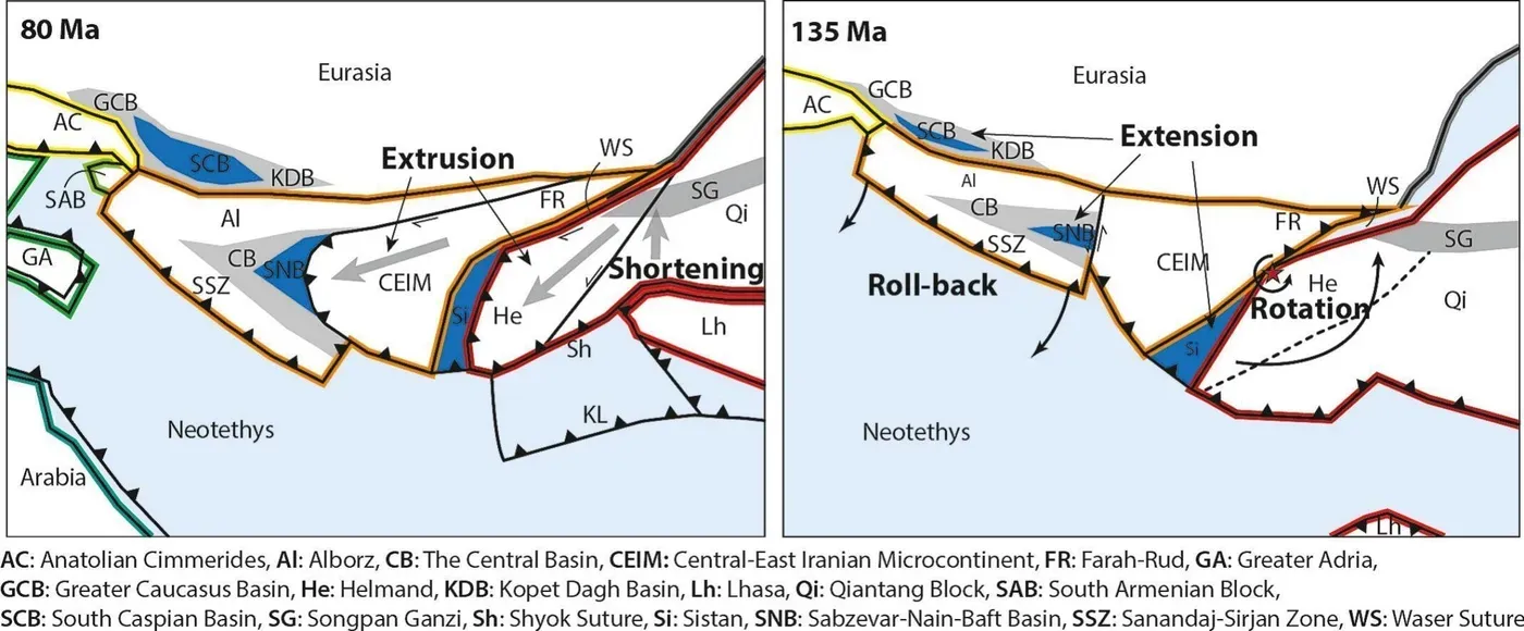
A complex sequence of events unfolded as different continents converged in the region, leading to the formation of unique geological features. The initial collision occurred when blocks from Iran that broke away from Arabia 270 million years ago came into contact with Europe some 50 million years later.
The region's tectonic history took another dramatic turn when Afghanistan's crust was squeezed westward out of the Tibetan Plateau and into Iran. This massive piece of crust was then compressed once again by the collision with India, resulting in a complex interplay of forces that shaped the area.
As if these events were not enough, Arabia itself collided with the region from the southwest. The collision zone near Iran saw the Arabian continent pushed down, creating the Persian Gulf and altering the course of regional tectonic activity.
The impact of this collision was felt far beyond the immediate region, as it also led to the formation of a mountain range in Oman that now forms a crescent-shaped ledge on the edge of the Arabian plate. Where this mountain range is pushed down, a bend was created in the Persian Gulf, resulting in the Strait of Hormuz.
The team's research has uncovered a complex geological history of the region, involving the movement and collision of ancient tectonic plates.
To reconstruct this history, Lom and his colleagues have been studying old fault systems, rotating pieces of crust, and remnants of former small oceanic basins that once existed in Iran.
By analyzing decades of geological literature, they found evidence of a past landscape where deep-sea basins separated Afghanistan from western Iran, giving the region a resemblance to the western Mediterranean.
The researchers have been using advanced software, specifically GPlates plate reconstruction software, to piece together this complex history step by step. This technology has proven invaluable in their study of the region's geological evolution.
This research is part of a larger series of reconstructions led by Van Hinsbergen, including those of lost continents and megaplates such as Greater Adria, Argoland, and Pontus.
The study published in Gondwana Research reconstructs a complex geological history of the Central Tethysides region, where Iran and Afghanistan meet. This area has experienced multiple phases of extension, subduction, and lateral extrusion over millions of years.
Geological processes have shaped the terrain of this crossroads, with tectonic forces pushing the Earth's crust upwards or downwards in a cycle of compression and decompression. The Central Tethysides region is characterized by a complex interplay of these processes, resulting in its unique landscape.
Facts based on reporting originally published by Phys.org.
You may republish this story, in full or in part, if you credit News Central Site and link to it (licence CC BY 4.0). Photos are not included.