New software tool simplifies access to global ocean datasets
A new software package called oceandatr has been developed to help scientists gather and analyze oceanic data more efficiently.
Scientists studying the ocean often face a daunting task: gathering relevant data from various sources to answer their research questions. This challenge is particularly true when trying to access information about seafloor depth, underwater mountain ranges, or sea surface temperatures.
A team of researchers has developed a new software tool designed to simplify this process and allow scientists to focus on analysis rather than data preparation. The software package, called oceandatr, was created using R, a popular programming language for data analysis. With just one command, users can access a wide range of global ocean datasets.
oceandatr enables the integration of various ocean-related datasets into a single platform. This allows scientists to quickly organize and prepare the data for further analysis or mapping. The tool's developers aim to facilitate research by streamlining the process of gathering and processing oceanic data.
The software is built on R, which is widely used in the field of data analysis. Its creation reflects the growing demand for efficient tools that can help scientists make better use of available data and resources.
The new tool, designed to streamline access to geospatial ocean data, has been developed by researchers from the University of California Santa Barbara's Environmental Markets Lab (emLab). The software, known as oceandatr, can help scientists quickly and easily obtain the data they need in a format that suits their research. According to lead author Jason Flower, the key benefit of oceandatr is its ability to provide researchers with the data they require without needing to write new code.
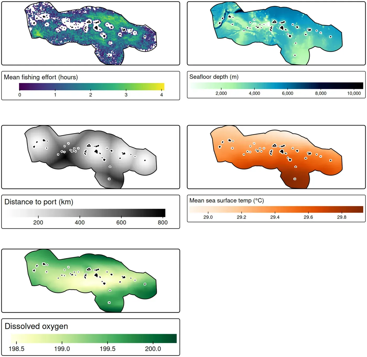
The team behind oceandatr drew on their experience working on marine spatial planning projects in small island nations such as Vanuatu and Fiji. In these contexts, researchers often need to combine data from various sources, including seafloor maps, temperature readings, and information about human activities like fishing. However, gathering this data can be a time-consuming process that involves writing custom code to merge the different datasets.
To simplify this process, Flower and his colleagues created oceandatr as an R package that organizes commonly used ocean data sets into ready-made functions. This means researchers can access the data they need with just one command, saving them time and effort. The software is hosted on GitHub and is available to download for free.
The development of oceandatr reflects a growing recognition of the importance of efficient tools in helping scientists make better use of available data and resources. By streamlining access to geospatial ocean data, the new package has the potential to support a wide range of research projects and applications.
The researchers behind oceandatr took an unconventional approach to developing this software package. Unlike many studies, they weren't trying to solve a specific research problem but rather create a tool that would simplify marine scientists' workflow when handling geospatial ocean data.
One of the key features of oceandatr is its ability to retrieve and combine various types of spatial ocean data sets. This includes information on seafloor depth, the location of underwater volcanoes known as seamounts, and sea surface temperature.
The researchers have demonstrated two potential applications for this software package in their study. They used ocean data to inform the planning of marine protected areas, ensuring that these reserves are established in locations that promote biodiversity while minimizing human impact on the ecosystem. In another example, they applied oceandatr to model and map where fishing activity is likely to occur.
A significant advantage of oceandatr lies in its capacity to standardize data from different sources. When working with multiple data sets, researchers often encounter issues due to variations in spatial formats or scales. For instance, bathymetry data retrieved by oceandatr has a resolution of 15 arc seconds, while data on fishing effort is coarser at 0.01 degree.
By standardizing these data behind the scenes, oceandatr enables users to focus on analysis without being bogged down by formatting issues. This streamlined process allows researchers to devote more time to interpreting and applying their findings in real-world contexts.
The software can handle data from both large and small areas, making it useful for researchers working on individual islands or coastal regions.
Researchers can supply their own data sets, which will be saved at the appropriate spatial scale by oceandatr.
Future additions to the software could include daily sea surface temperature data, in addition to the average sea surface temperature information already available.
The developers aim to make the software more efficient and faster so that it remains accessible to researchers using older or slower computers.
The free software, oceandatr, is designed to streamline the process of gathering and preparing geospatial ocean data for researchers.
This should allow scientists to focus on analyzing the data and answering complex questions about ocean ecosystems, rather than spending time on repetitive tasks such as data collection and processing.
By automating these tasks, the software aims to make it easier for researchers to access and utilize large datasets, potentially leading to new insights into ocean phenomena.
Facts based on reporting originally published by Phys.org.
You may republish this story, in full or in part, if you credit News Central Site and link to it (licence CC BY 4.0). Photos are not included.