Hurricanes Madeline and Lester Approach Hawaii
A satellite image captures the twin cyclones barreling towards the Hawaiian Islands in August 2016.
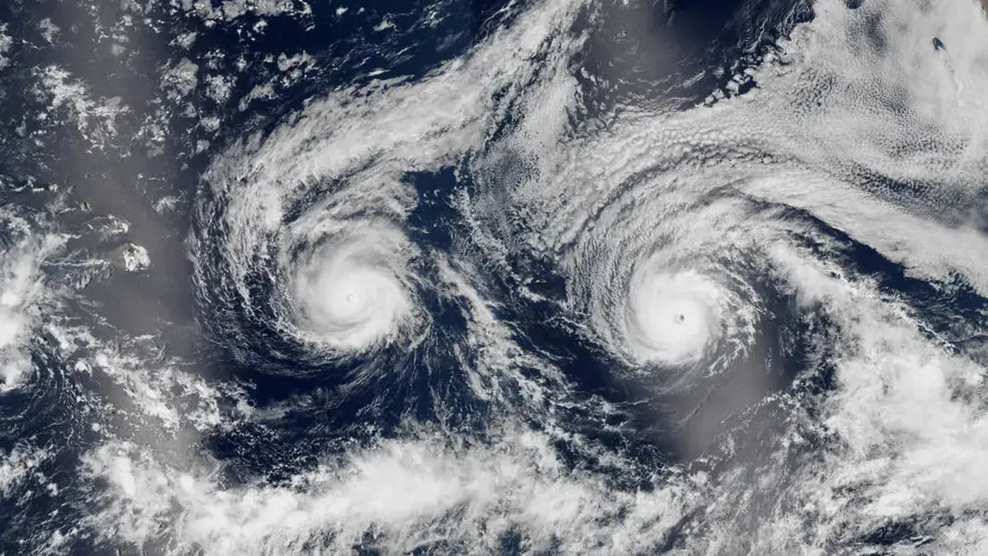
Two hurricanes are heading towards Hawaii, with a unique and unsettling visual effect. A satellite image taken in August 2016 captures the eerie sight of Hurricane Madeline on the left and Hurricane Lester on the right.
The Suomi NPP satellite captured the image, which shows the twin cyclones barreling towards the Hawaiian Islands. The swirling clouds around the storms give them a haunting resemblance to a pale face smiling up at space.
On a weather map, the symmetry of the two storms is even more striking, with Hurricane Madeline on the left and Hurricane Lester on the right. This unusual visual effect makes the image stand out from other satellite photos of hurricanes.
The Pacific hurricane season in 2016 was particularly active, with 22 named storms, tied for the sixth-most-active year on record. Hurricane Madeline reached its peak as a Category 4 storm on August 30, with maximum wind speeds of around 130 mph.
As the twin hurricanes barreled towards Hawaii, meteorologists were unsure if they would make landfall on the island. The Central Pacific Hurricane Center issued a hurricane warning for the state of Hawaii, cautioning that Madeline was likely to pass "dangerously close to the Big Island.
The radar-based weather map offered an eerie sight as the hurricanes appeared to stare up into space. This visual illusion belied the reality that neither storm ultimately made landfall in Hawaii. Instead, Madeline passed south of the islands on August 31, having been downgraded from a Category 4 to a Category 1 hurricane.
The closest approach was made by Lester, which came within approximately 130 miles (210 km) of Honolulu before turning sharply northward and dissipating. Despite not making landfall, both hurricanes brought high winds, heavy rainfall, and strong surf to the state.
Hawaii's unique geography makes it less susceptible to hurricane landfalls due to two main factors. The islands are surrounded by high-pressure systems on their eastern side, where most hurricanes originate, creating a barrier that steers storms away from the state. Additionally, strong winds often blow eastward across the islands, further contributing to the region's relative immunity to hurricanes.
This invisible shield around Hawaii allows the state to dodge the worst effects of hurricanes, with only a few instances where storms come close enough to trigger strong gusts of wind on the islands. However, recent changes in global and regional weather patterns may soon alter this trend.
The increasing frequency of extreme weather events worldwide, largely attributed to human-caused climate change, poses a growing threat to Hawaii's hurricane-resistant status. This shift is expected to continue, potentially leading to more frequent close encounters between hurricanes and the islands.
Recent examples include Hurricanes Lowell and Lala, which skimmed perilously close to Kauai in August and September, causing significant damage to power lines, boats, and coastal infrastructure on the island.
The ongoing super El Niño event has been linked to a surge in intense weather patterns globally, and researchers believe it may be contributing to the recent twin hurricanes threatening Hawaii. Officially beginning in May, this year's El Niño has already set records for sea surface temperatures in the Pacific Ocean.
Satellite imagery has captured breathtaking examples of unusual cloud formations around the world, including swirling dark spots over Antarctica, a rare Bull's-eye cloud above an erupting volcano on La Palma, and stunning von Kármán vortices" off Atlantic islands. These remarkable displays underscore the complexity and diversity of atmospheric phenomena.
The convergence of these factors has led to an increased risk of intense weather events like Hurricanes Lowell and Lala, which recently threatened Hawaii's Kauai island with significant damage. The situation highlights the importance of monitoring global climate patterns and understanding their impact on local weather conditions.
Facts based on reporting originally published by Live Science.
You may republish this story, in full or in part, if you credit News Central Site and link to it (licence CC BY 4.0). Photos are not included.