Satellite Image Reveals Taiwan's Compact Mini Farms
A recent satellite image of Taiwan's largest river basin has captured a striking multicolored mosaic of tightly compacted mini farms.
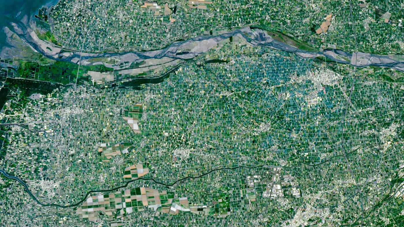
A striking multicolored "mosaic" of tightly compacted mini farms has been captured in a recent satellite image of Taiwan's largest river basin. The photo, taken by Landsat 9, reveals a vast expanse of fields and shade nets covering the Chianan Plain.
Taiwan, located in the western Pacific Ocean, is an island with limited land area to accommodate its large population. With approximately 23 million people living on the island, Taiwan's agricultural industry faces significant challenges in providing enough food for everyone. The island's size is roughly equivalent to that of Maryland, but its densely populated nature puts a strain on available farmland.
Researchers have estimated that there are only about 3,200 square feet (300 square meters) of farmland per citizen in Taiwan, an area roughly two-thirds the size of a basketball court. This is significantly less than the amount of land allocated to agriculture for each U.S. citizen.
The island's topography also contributes to the scarcity of arable land. Large parts of Taiwan are covered by mountains and rainforest, leaving limited space for farming.
Yunlin County in Taiwan is a prime location for agriculture due to its flat terrain and access to water from the Zhuoshui River.
The county's landscape is ideal for growing a diverse range of crops, including rice, sweet potatoes, peanuts, corn, sugarcane, garlic, scallions, coffee, fruit, and leafy greens. This variety can be attributed to the favorable conditions provided by the Chianan Plain, a long strip of flat land along Taiwan's west coast.
The average farm size in Yunlin County is remarkably small, spanning under 100,000 square feet. For comparison, this is about 90 times smaller than the typical farm size in the United States.
This large number of tiny farms contributes to the region's distinctive appearance when viewed from space, creating a patchwork of irregularly shaped fields that resemble a giant mosaic. The small farm sizes are partly due to legislation that limits land ownership.
The farming landscape in Yunlin County is also characterized by its consistency across the area, although two distinct regions stand out from the rest.
The farming landscape in Yunlin County is characterized by its consistency across the area, although two distinct regions stand out from the rest. One of these anomalies is a cluster of blue and turquoise rectangles surrounding the town of Xiluo in the upper right of the image. These rectangular fields are covered with plastic shade nets to protect them from harsh summer sunlight and monsoon-like rains during the wet season.
The second anomaly is a group of larger, lightly colored farms near the town of Baozhong, located at the bottom left of the photo. These farms have a distinct appearance compared to the surrounding landscape, suggesting that they may be used for a different purpose or have undergone significant changes over time.
Historical records suggest that this region was once extensively used for sugarcane cultivation during Japan's control of Taiwan between 1895 and 1945. The Japanese also built railway lines to transport the crop across the island. Although most of these fields have been repurposed, remnants of the past remain visible in the landscape.
The small farms in Yunlin County are not only used for growing crops but also serve as a source of livestock, including chickens, cattle, and millions of pigs. This diversification of agricultural activities contributes to the county's overall economic stability and resilience.
These diverse farming practices and regional characteristics contribute to the rich tapestry of Taiwan's landscape, making it an interesting subject for satellite imaging and Earth observation research.
The diverse farming practices in Taiwan have created a unique landscape that is highly visible from space. This phenomenon can be attributed to the country's geography and climate, which allow for a wide range of agricultural activities. The varying elevations and slopes of the terrain enable different types of crops to be grown in close proximity.
Taiwan's largest river, the Jiulong River, surrounds a mosaic of mini farms that are easily distinguishable from space due to their distinct patterns and colors. Satellite imaging and Earth observation research have greatly benefited from studying this region. The combination of diverse farming practices and regional characteristics makes Taiwan an interesting subject for scientists and researchers.
The intricate network of farmland surrounding the Jiulong River contributes significantly to Taiwan's rich cultural heritage and economic prosperity, making it a valuable area of study for those interested in sustainable agriculture and environmental management.
Facts based on reporting originally published by Live Science.
You may republish this story, in full or in part, if you credit News Central Site and link to it (licence CC BY 4.0). Photos are not included.